

Interactive maps in the service of archaeological and cultural heritage sites
myEleusis.MAP is an application that is implemented within the myEleusis project, seeking to transfer the passer-by or the visitors of the area to the atmosphere of the Eleusinian Mysteries era. Following the route along the Sacred Way (Iera Odos) from Athens to Eleusis, the map will enable them to travel through time, in an informative, educational and entertaining way to a past, which remains very much alive, through its ruins. On interactive online maps, such as myEleusis.MAP, we can geographically locate any point of interest and enable the user to interact in a variety of ways. For sites of archaeological importance and monuments with centuries of life, the creation of such interactive maps enables the user, on-site or via remote connection, to navigate through space and time in a personalized way by setting filters and through targeted searches. Thus, information of historical and archaeological interest concerning the places they choose are a few "clicks" away no matter where they are located.
It is easy to reckon the possibilities that open up with such technologies towards the dissemination of archaeological knowledge and the greater visibility of the monuments, not only to the physical visitors but to anyone from anywhere in the world. At the same time, the in situ visit is embellished and enriched with material that is not offered through a typical visit to an archaeological site. After all, modern visitors tend to move away from the passive-receiver model and seek to interact with the environment, searching for specialized data and choosing for themselves how to classify the material they receive, based on their interests.
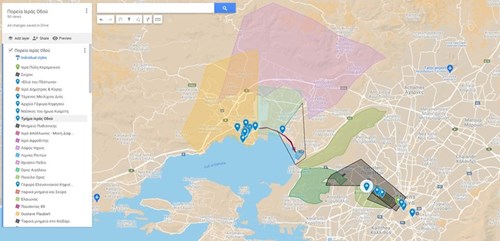
With myEleusis.MAP users may follow the path along the Sacred Way, from Dipylon of Kerameikos to the sanctuary of Demeter and Kore, Persephone, at the archaeological site of Eleusis, and may retrieve information about the monuments that exist along this route, within the archaeological site and around the city of Eleusis. Also, the map design shall give the user the opportunity, like an initiate of the past, to experience the ambience of the era of the Eleusinian Mysteries.
The interactive map of myEleusis, myEleusis.MAP, which is curated by the team of the cultural management company MENTOR in collaboration with the Ephorate of Antiquities of West Attica, will bring new life to the entire route followed in antiquity during the Eleusinian Mysteries. Combined with the rest of the digital applications of myEleusis, the project will enrich the experience of visiting (before, during and after) the archaeological site and the city of Eleusis in a dynamic and unique way for each visitor.
